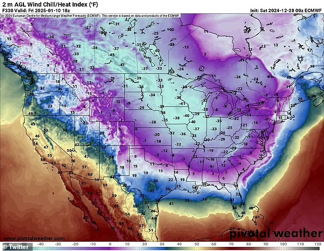
Meteorologists are forecasting a dramatic shift in temperatures as a polar vortex is set to plunge the eastern United States into an extended period of bitter cold. This upcoming weather event could make January 2025 the coldest in over a decade, rivaling the infamous polar vortex of January 2014. The shift follows an unusually warm December, amplifying the stark contrast as temperatures begin to drop.
What Is a Polar Vortex?
A polar vortex refers to a massive, low-pressure system of cold air that normally circulates around the polar regions. Occasionally, disruptions in this system can cause it to expand and send frigid Arctic air southward. When this happens, regions across the U.S. can experience dramatic drops in temperature, sometimes accompanied by severe winter storms.
This phenomenon, while not uncommon in winter, has the potential to bring record-breaking cold. Meteorologists warn that this event could extend over several weeks, bringing persistent frigid conditions from the Midwest to the Gulf Coast and as far east as the Atlantic seaboard.
Cold Air to Grip Half the Nation
According to forecasts, temperatures will begin dropping significantly this week. The effects of the polar vortex will become most pronounced over the next seven to fourteen days, with some areas expected to experience temperatures 20 to 30 degrees below seasonal averages.
- Midwest: Cities like Chicago, Minneapolis, and Detroit are bracing for below-zero wind chills. Daytime highs may struggle to climb out of the single digits, while overnight lows could dip into the negative double digits.
- Northeast: New York City and Boston are likely to see daytime highs in the 20s, with potential for snowstorms as Arctic air collides with coastal moisture.
- South: The Gulf Coast states, including Texas and Florida, could experience freezing temperatures. Parts of Florida might even face frost or light snow, an extremely rare occurrence for the Sunshine State.
Snow and Ice Threats
Meteorologists are also warning of the likelihood of major winter storms accompanying the cold snap. The Southeast, which is unaccustomed to severe winter weather, may face snow or ice events, particularly from mid-to-late next week. These storms could disrupt travel, cause power outages, and create hazardous road conditions across the region.
The convergence of Arctic air with active weather systems in the Atlantic has the potential to produce significant snowfall in the Northeast and mid-Atlantic states. This could add to the challenges posed by the already frigid temperatures.
How Long Will the Cold Last?
Unlike some cold snaps that dissipate after a few days, the effects of this polar vortex are expected to linger through most of January. Weather models suggest that the pattern will remain locked in place, with only minor fluctuations in temperatures. Relief from the extreme cold may not come until February.
“This is shaping up to be one of the longest and most severe cold waves we’ve seen in years,” said a leading meteorologist. “The consistency in weather models is unprecedented, and we’re advising everyone to prepare for an extended period of winter weather.”
Historical Context
The polar vortex of January 2014 brought record-low temperatures and widespread disruptions. States like Georgia and Alabama experienced unprecedented cold, with temperatures dropping into the teens and single digits. The event resulted in over 20 fatalities and billions of dollars in economic losses.
Meteorologists are comparing the upcoming event to the 2014 cold wave, noting similarities in atmospheric patterns and temperature forecasts.
Preparation and Safety Tips
Residents in affected areas are urged to take proactive measures to prepare for the cold snap:
- Home Preparation:
- Ensure heating systems are functioning properly and stock up on heating supplies like firewood or fuel.
- Seal windows and doors to prevent drafts and conserve energy.
- Keep a backup generator or alternative heat source in case of power outages.
- Personal Safety:
- Dress in layers, including hats, gloves, and thermal clothing, to retain body heat when outdoors.
- Avoid prolonged exposure to the cold, which can lead to frostbite or hypothermia.
- Travel Precautions:
- Carry an emergency kit in your vehicle, including blankets, food, water, and a flashlight.
- Monitor road conditions and delay non-essential travel during winter storms.
- Pets and Livestock:
- Provide adequate shelter for animals and ensure they have access to food and unfrozen water.
Impact on Communities and Infrastructure
The anticipated cold wave has already prompted local and state officials to prepare emergency measures. Warming shelters are being set up in major cities to assist vulnerable populations, including the homeless and elderly. Utility companies are bracing for increased demand on energy grids, which could lead to localized blackouts.
Airports in affected regions are preparing for potential disruptions due to snow and ice. Travelers are advised to check flight statuses and prepare for delays or cancellations.
Looking Ahead
As the polar vortex looms, the nation is preparing for a challenging start to the new year. This prolonged cold snap will test the resilience of communities, infrastructure, and individuals alike. While the exact severity of the cold remains to be seen, experts agree that this event will be one for the history books.
This is a developing story. Stay tuned for updates as the polar vortex unfolds.

